
|
I am a PhD student in Cartography and Geographical Information System from School of Geography and Planning, Sun Yat-Sen University, starting in September 2024 and supervised by Prof. Haicheng Zhang. I received my B.S. in Geographic Information Science from School of Geography and Planning, Sun Yat-Sen University in June 2024. Meanwhile, I also minored in Statistics from School of Mathematics, Sun Yat-Sen University from September 2021 and finished in June 2024. My research is primarily focused on remote sensing images interpretations and applications, especially in very high resolution (VHR) mapping, multi-source remote sensing images fusion, coastal ecological remote sensing analysis and global change. Currently, I am engaged in research with remote sensing images interpretations with deep learning and geospatial big data analysis in global change. CV / Google Scholar / GitHub |
|
My current research topics include remote sensing images interpretations and applications, focusing on very high resolution (VHR) mapping, multi-source remote sensing images fusion, coastal ecological remote sensing analysis and global change. |
|
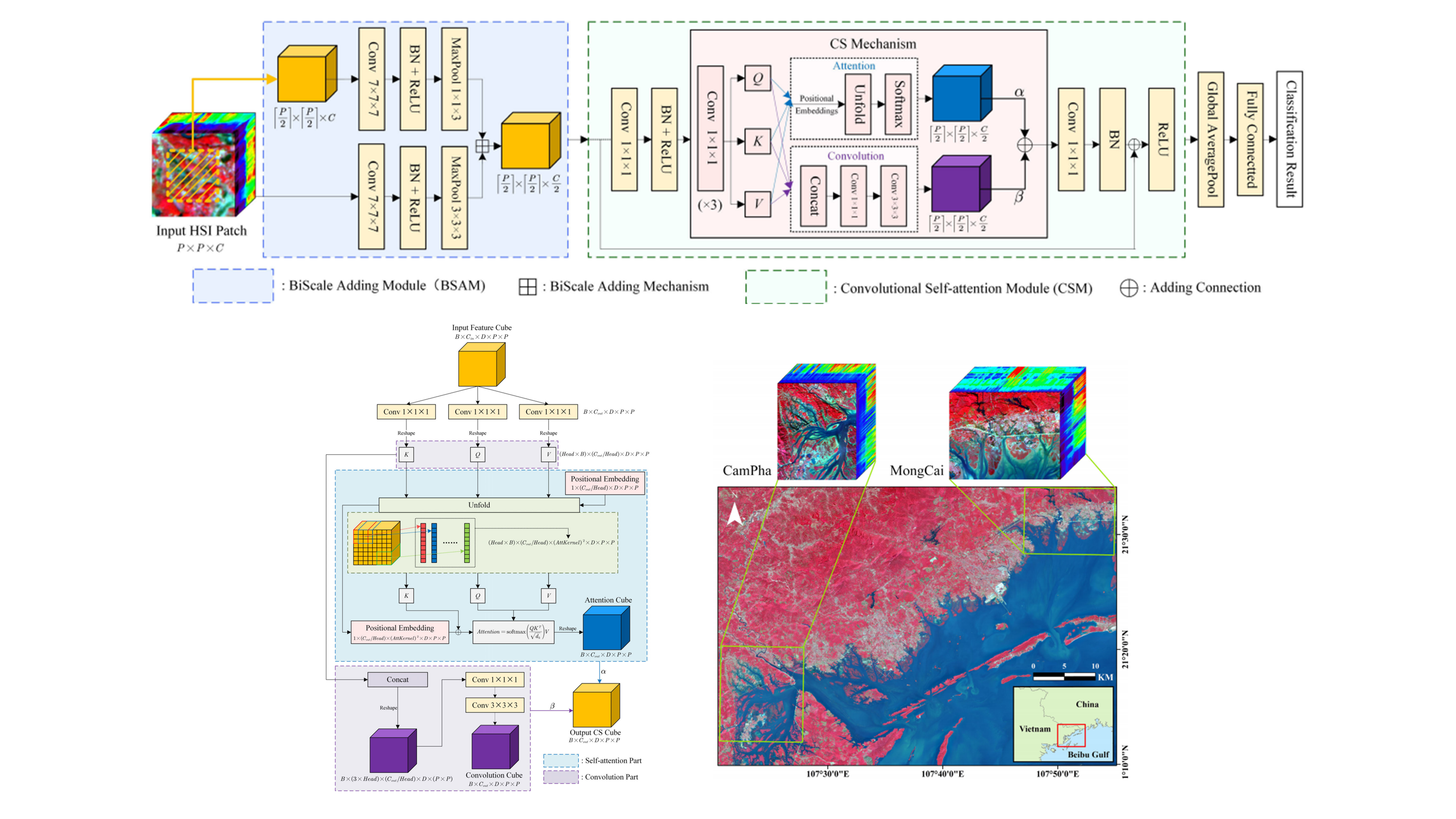
Junshen Luo, Zhi He, Haomei Lin, Heqian Wu IEEE Geoscience and Remote Sensing Letters (GRSL), 2024 IEEE Xplore / GitHub Code |
|
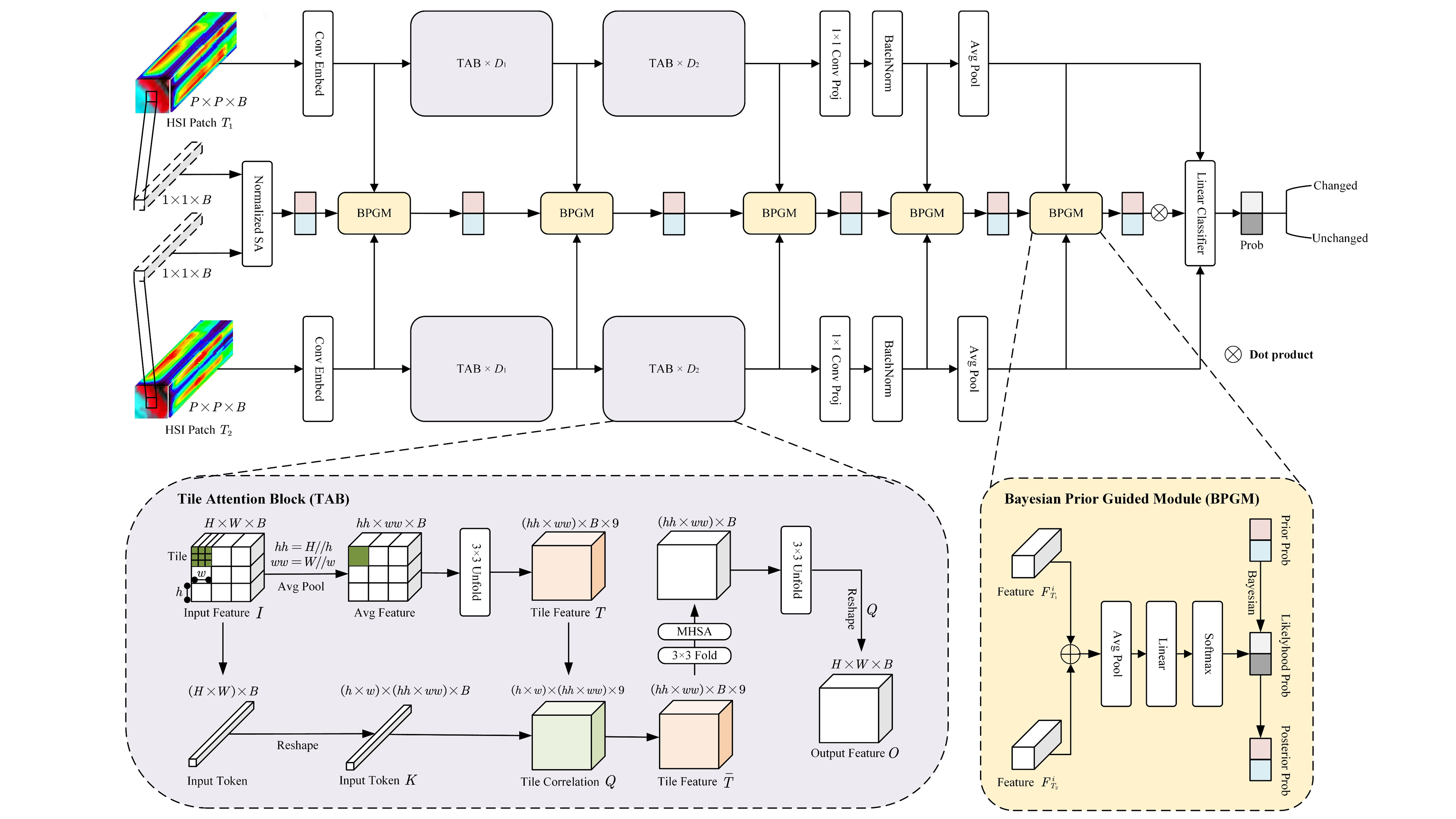
Junshen Luo, Jiahe Li, Xinlin Chu, Sai Yang, Lingjun Tao and Qian Shi IEEE Geoscience and Remote Sensing Letters (GRSL), 2025 IEEE Xplore / GitHub Code |
|
Haoyang Li, Haomei Lin, Junshen Luo, Teng Wang, Hao Chen, Qiuting Xu, Xinchang Zhang IEEE Journal of Selected Topics in Applied Earth Observations and Remote Sensing (JSTARS), 2023 IEEE Xplore / Part of GitHub Code |
|
National Innovative Training Project for College Students in 2022 Keywords: Abandoned Cropland Extraction, Spatial Analysis, Field Interview, Push-Pull Theory Landsat RS images from 2000-2015 and random forest algorithm is applied to obtain landcover, abandoned cropland and fragmentation of cropland for Shaoguan City. Combining multi-source GIS data, different rural regional system types and the degree of rural space shrinkage are identified. Eventually, taking three natural villages as examples, the spatial shrinkage processes are deeply analyzed through UAV images analysis, semi-structured interviews and field observations. |
|
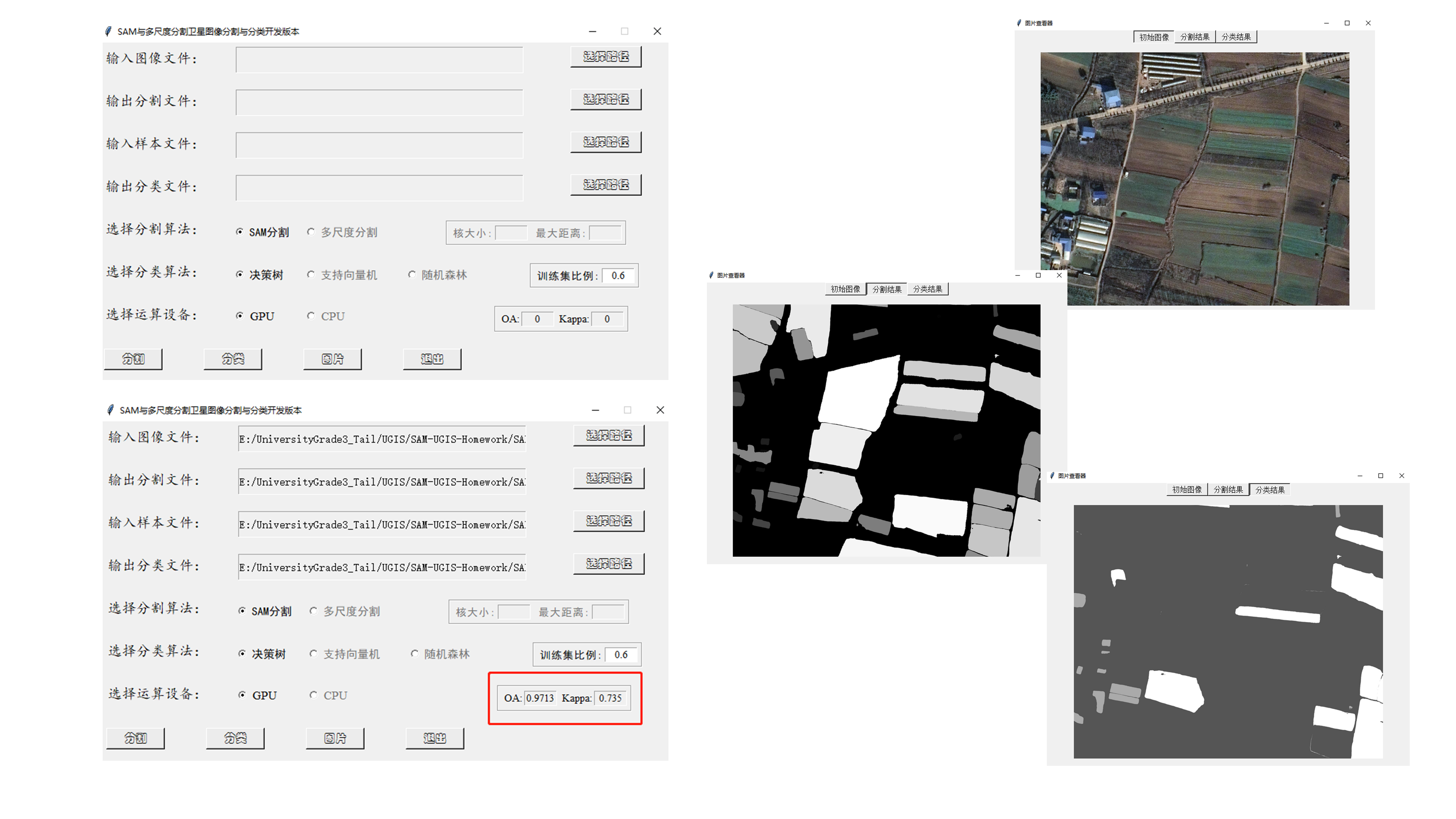
Course Project of SYSU GP2160: Project on Geospatial Segment Anything App Development Keywords: Tkinter Development by Python, Segment Anything Model, Multi-Scale Segmentation Utilized segment-geospatial package and segment-anything api to develop a mini app for RS images segmentation and classification by tkinter framework in Python. Morever, multi-scale segmentation and serveral machine learning classification algorithm were also provided in the mini app. The code of the Geospatial Segment Anything Mini App is avaiable at the repository . |
|
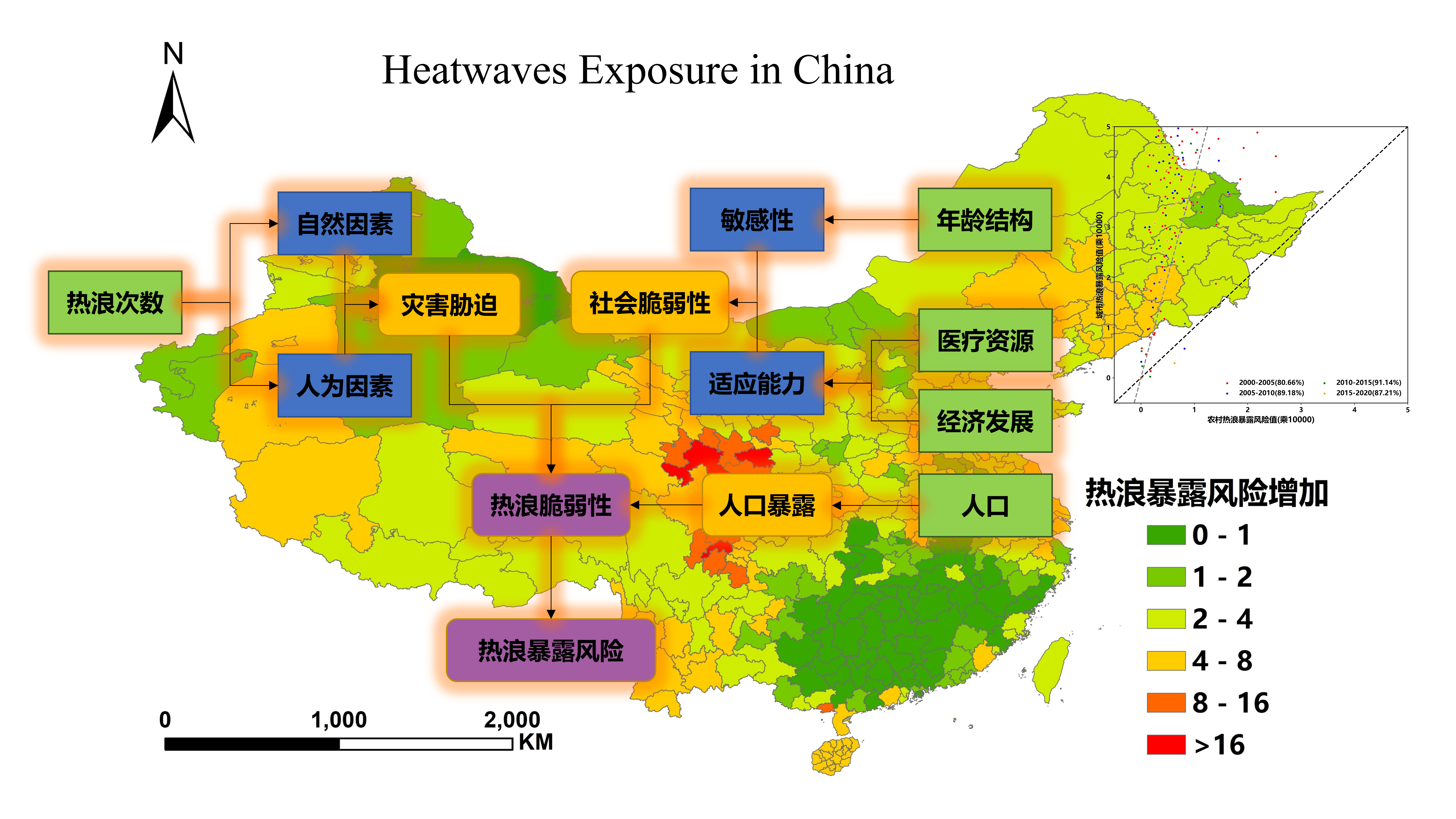
Course Project of SYSU GP3013: Project on Heatwaves Exposure in China Keywords: Multi-Source GIS Data Fusion, Urban and Rural Cities Clustering Based on "Disaster-Vulnerability-Exposure" analysis framework, multi-source GIS data including time series of LST dataset, China Statistical Yearbook and its reanalysis medical dataset, Landscan Global dataset and Global gridded revised real GDP dataset were used to calculate heatwaves exposure in China. The different effects of heatwaves exposure between urban and rural cities were also explored. |
|
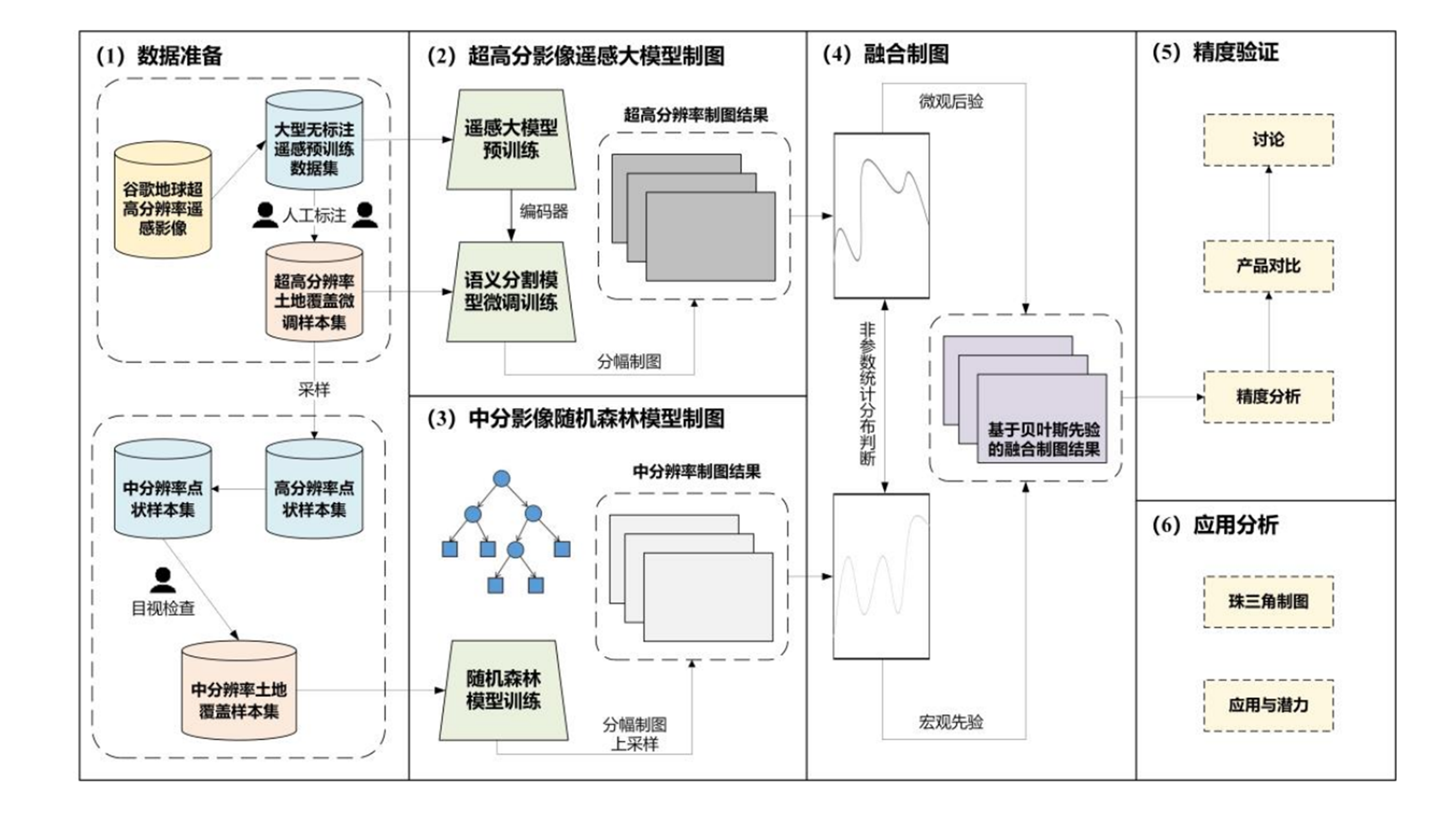
2024 Undergraduate Thesis of Science in Geographic Information Science of SYSU Keywords: Remote Sensing Large Model, VHR Mapping, Multi-Source Remote Sensing Data Fusion Taking the Pearl River Delta (PRD) as the example, used remote sensing large model and multi-source remote sensing data (Sentinel-1/2, Google Earth) for 1m VHR land cover mapping. Proposed a VHR 1m land cover mapping framework based on RSLM and multi-source remote sensing data fusion and then produced a VHR 1m land cover mapping dataset of the PRD including nine cities. |
National Scholarship |
Ministry of Education of the People's Republic of China 2023 |
First-Class Academic Scholarship |
Sun Yat-Sen University 2023,2024 |
Third-Class Academic Scholarship |
Sun Yat-Sen University 2021,2022 |
|
Modified version of template from here Last updated: 22 Nov. 2024 |